home | tipos de suelos | cartografía | edafogalería | estudio del suelo
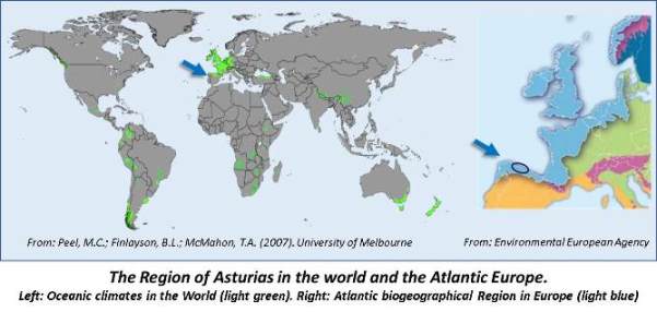
Soil Atlas of Asturias (Spain)

The Asturias Region, located in the Cantabrian area in northern Spain, brings together many of the characteristics of the European Atlantic regions related to climate, lithology, geomorphology, vegetation and land use. As a consequence of the variation in altitude (from 0 to> 2500 m), some of these characteristics, such as a particular Oceanic climate, express great contrasts: annual rainfall of about 1000 mm in the lowland valleys, which rises to almost 2000 mm in mountainous areas. On the other hand, the mild annual average temperatures (around 15º C) registered in coastal areas and low valleys, drop to less than 5º C in wide areas of high altitudes. Likewise, a very complex geology implies a great spatial variation of the rocks that appear on the surface: limestones, quartzites, sandstones, clays, or very different types of quaternary deposits. It also involves contrasting slopes and landforms, with a mix of karst, glacial, coastal, alluvial, and colluvial geomorphological processes.

In short, such characteristics imply a "high concentration" of soil-forming factors. Therefore, Asturias shows a high variability of soils, with a corresponding rich taxonomy. In our case, in an area of about 1,650 km2 in eastern Asturias, and according to the Soil Taxonomy classification system, 7 soil orders and 65 soil subgroups have been identified.

This work tries to show and highlight the natural heritage represented by the soils of Asturias, with special emphasis on the presentation of soil profiles and landscapes with explanatory texts, and the description, for informative and educational purposes, of different topics of Soil Science. In this home page, five options are available:

  • "Tipos de suelos" (Soil types): includes the Soil Orders of the USDA's Soil Taxonomy that have been identified in the Asturias Region. They are presented and explained using images of soil profiles corresponding to 7 soil orders, 16 suborders, 26 groups and 60 soil subgroups.

  • "Cartografía de los suelos de Asturias" (Soil mapping in Asturias): includes information on the Soil Mapping Project, at a scale of 1: 25,000, which is currently being carried out with the support of the Government of the Principality of Asturias. This option shows other related studies and soil information available in the area.

  • "Edafogalería" (Soil Gallery): consists of two parts; the first, “Galería de perfiles edáficos” (Soil Profile Gallery), contains a description of 20 soil profiles, which represent the main soil subgroups studied in eastern Asturias. By clicking on two links: “Horizontes de diagnóstico” (Diagnostic Horizons), and “Procesos edafogenéticos” (Pedogenetical processes), a large number of images are shown and explained. The second part is called “Los suelos en el paisaje” (Soil landscapes), where 57 images of typical landscapes related to 23 soil Groups are shown.

  • "Estudio y clasificación del suelo" (Soil Study and Classification): consists of two parts: “El estudio de los suelos”, which describes general topics related to field and laboratory tasks in soil studies, and “Clasificación del suelo”, which provides information on the use of the major soil classification systems: the USDA Soil Taxonomy and the FA0-WRB Soil Resources Reference Base.

  • "Evaluación de los suelos de Asturias"(Soil Assesment in Asturias): this option provides a link to a detailed on-line “Map of Sustainable Soil Uses”, based on the concept of Agro-ecological zoning developed by FAO. This complete map is included in the Territorial Information System of the Principality of Asturias (SITPA).

Blanco
aviso legal | contacto | ficha técnica
CCPA
© Gobierno de Asturias